


CFI Tools AreaWx app for iPhone and iPad
Developer: Edgemont Systems
First release : 10 Feb 2010
App size: 3.42 Mb
PLEASE NOTE: This App has been retired but remains in the store for existing customers and very limited maintenance. It has been replaced by the General Aviation App.
------------------------------------
CFI Tools Area Weather - AreaWx
-----------------------------------
PURPOSE: The Area Weather App is used to check METARs and TAFs plotted on a color-coded map, an enhanced text table or in raw data format. The weather is displayed for all METAR stations within the specified area. The area is defined by a METAR station and a radius around the station.
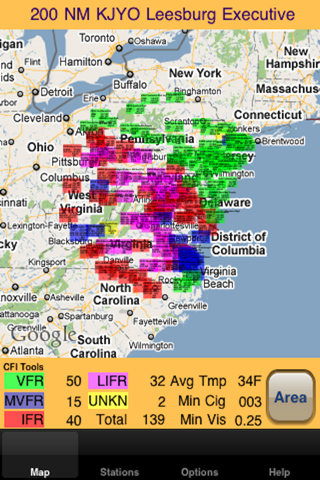
METARs on a Map
-----------------
The METAR data is displayed on a map that adjusts based on the size of the area. The METARs are colored coded based on the aviation flight category (VFR, MVFR, IFR, LIFR) for the station. The color coding and placement on the map gives a good quick overview of the current weather in the area.
METARs in a Table
-------------------
The METAR data may also be displayed in a table that allows more detailed viewing for stations in the area. The stations are sorted based on their distance from the base station. Tap any station in the table to see the complete raw data for the METAR and if available TAF.
METARs and TAF raw data
----------------------------
A simple display of the raw METAR and TAF data. This includes up to 36 hours history for the station.
How it works
----------------
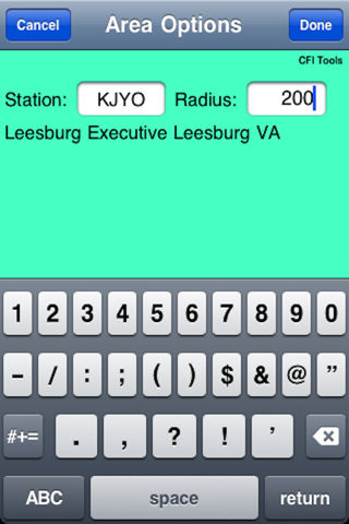
Touch the "AREA" button to define the Area.
The Area is defined by entering the ICAO identifier for the station. There is a fast search function that allows search by ID, airport name or city. After a station is chosen simply enter the radius and touch Done.
An internet connection is required to get the METAR data.
Options Tab
--------------
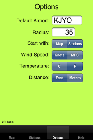
You can select a default Airport and Radius to be loaded at startup as the default Area.
You can have the App start-up on either the Map tab the Stations Table tab or the raw data tab.
Measurement units for Wind speed, Temperature and Distance and amount of history can be set on the Options Tab.
Airports in the Database
--------------------------
PLEASE NOTE: The source of the METARs used in this App is NOAA’s National Weather Service Aviation Weather Center. It can be found here:
http://aviationweather.gov/adds/metars/
If the METAR station can not be found with this site, it will not be in the App.
As Always
----------
Make sure that any Weather information is verified using the approved weather sources.
Please Note
-------------
This App has been thoroughly tested with MEATAR information from around the world. However I want to emphasize the need to verify this data.
One thing that you may not realize is that METAR data may be entered by hand. That means that it is possible that there could be typos or simply some added information that is not expected by the software. This added information could cause unpredictable results and the user should be alert to this possibility.
PLEASE NOTE: This App has been retired but remains in the store for existing customers and very limited maintenance. It has been replaced by the General Aviation App.
----------------
About CFI Tools
----------------
Im a Pilot and a CFII. I build these iPhone Apps and other software for my own use.
Some other pilots saw them and said "Hey you should sell those".
So here they are for sale. I hope you enjoy them. Any suggestions for improvement or new apps are always welcomed. Have a good flight.